Browse Items (308 total)
- Collection: Empire Ranch
Sort by:
ERPhotoAlbum2.201

Rancher and cow in pen at Empire Ranch.
ERPhotoAlbum2.202

Cowboys on horseback in pen at Empire Ranch.
ERPhotoAlbum2.203
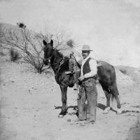
Harry Landon Heffner 1893 Empire Ranch.

1880 Rand McNally & Co.'s Arizona Map
1880 map of Arizona shows the seven counties at the time: Mohave, Yavapai, Apache, Yuma, Maricopa, Pinal, and Pima. The Empire Ranch location is shown on this map in Pima County.
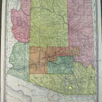
Territory of Arizona Map, 1883

1883 map of Arizona Territory shows the location of the Fish Ranch, also known as the Empire Ranch, which was purchased by Walter Vail and his partner in 1876. In 1880, the Southern Pacific Railroad arrived in Arizona. This map shows the routes of…
Territory of Arizona Map, 1883, Close Up
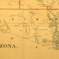
Close up of the 1883 map of Arizona Territory showing Pima County and the location of the Fish Ranch.
September 1, 1897 Lease and Let Agreement for the Rosemont School
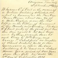
Edward L. Vail agreed to lease a building he owned for the Rosemont School at the rate of ninety-five dollars per year. The building was located on the Fair View Placer Claim approximately 1/4 mile east from the Post Office in the Village of…
Map of the lands of the Empire Cattle Co. in Pima County, Arizona, 1905
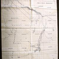
Following the 1803 Louisiana Purchase, the Federal government started surveying the West with the intention of selling as much land as possible to the public. The system used divided land into thirty-six single-square-mile sections. Each section…
1906 Rand McNally & Co.'s Arizona map

This 1906 map of Arizona shows thirteen counties and railroad routes. Included on the map is the town of Vail, which was named for Walter Vail, who deeded land to the railroad for its stop. The Empire Ranch location is not shown on this map as it was…